I'd rather be flying !
Nguyên văn bởi Cowboy72A

FORT LAUDERDALE, Fla. (AP) — People along the East Coast entered better-safe-than-sorry mode Tuesday, flocking to hardware stores, grocery aisles and gas stations as Hurricane Matthew marched toward Florida, threatening to become the first hurricane to hit the state's Atlantic coast in over a decade.
The storm was on track to rake the Southeastern coast and trek north. South Carolina Gov. Nikki Haley said she planned to issue an evacuation order Wednesday so that 1 million people can safely leave the coast.
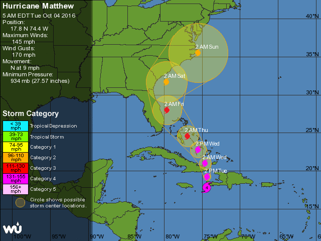
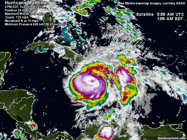
Matthew, a Category 4 storm packing winds of 145 mph, pummeled parts of Haiti and the Dominican Republic on Tuesday and is expected to head north over Cuba and the Bahamas before nearing the Florida coast by Thursday. At least seven people in the Caribbean have died.
The National Hurricane Center in Miami issued a hurricane watch for a 230-mile stretch from Deerfield Beach near Fort Lauderdale to the Daytona Beach area, meaning hurricane force winds of 74 mph or higher could occur within two days. A tropical storm watch was issued from the Seven Mile Bridge in the Florida Keys to Deerfield.
The White House said federal officials were deployed to state emergency operations centers in Florida, Georgia, South Carolina and North Carolina, where a state of emergency was declared a day earlier.
In South Florida, lines at grocery stores were heavier than usual and some essentials were in short supply. When Simone Corrado and her husband tried to buy water at their Publix in Davie near Fort Lauderdale, they mostly found empty shelves. There were a few bottles of high-end water brands, but there was so much empty shelf space that Corrado lay down and fully stretched out on the bottom shelf.
"I got scared because all that was left at Publix was just the pricey water," said Corrado, who lived through 1992's catastrophic Hurricane Andrew, which practically leveled the nearby city of Homestead. "They really put the fear into you here. On the television screen every few minutes is the 'beep, beep, beep' storm alert."
Gov. Rick Scott, speaking in the Daytona area, warned residents they must be prepared to take a direct hit and evacuation orders could be issued as early as Tuesday. Scott said his biggest worry is that residents won't take seriously the threat from Matthew, especially since so many newer residents have never lived through a hurricane.
"Don't take a chance. Leave before it's too late," he said. "We have to be prepared to be hit by a catastrophic hurricane."
South Carolina Gov. Nikki Haley declared a state of emergency today and said medical evacuations have begun for residents living along the coast. The evacuation is expected to affect nearly 1.1 million people.
Schools and government offices will be closed tomorrow in South Carolina, and Haley recommended that residents move at least 100 miles from the coast.
North Carolina Gov. Pat McCrory declared a state of emergency for 66 counties in his state in anticipation of Matthew's arrival Thursday night. He said he has been in contact with FEMA to prepare for the storm.
"I'm hoping this is a false alarm, but we can't gamble," McCrory said.
OMG
Tống ga ... đạp thắng và quẹo mặt ... bớt ga và vòng lại Florida!!!
Đúng là một cơn bão điên !
Mandatory evacuations South Carolina
South Carolina Gov. Nikki Haley gave evacuation orders for the coastal counties of Charleston and Beaufort starting Wednesday.
The threat in South Carolina is so severe that schools and government offices in 25 counties are closed Wednesday. Some schools will double as evacuation shelters.
In addition to the evacuation orders for Charleston and Beaufort counties Wednesday afternoon, Haley ordered Horry and Georgetown counties to evacuate by Thursday morning.
The South Carolina Department of Transportation has started changing the directions of traffic lanes to accommodate the exodus of people leaving coastal cities like Charleston.
Lanes on Interstate 26 were reversed Wednesday afternoon to help residents flee.
Hurricane Matthew could have devastating effect
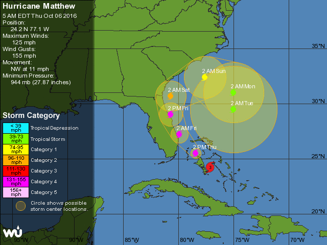
Hurricane Matthew Steadily Intensifying, Likely to be a Category 4 Storm for Florida
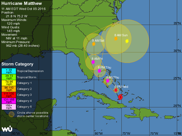
Powerful Category 3 Hurricane Matthew has steadily intensified over the warm waters of The Bahamas, and is poised to become a Category 4 hurricane this afternoon. An Air Force hurricane hunter aircraft penetrated Matthew’s eye at 8:17 am EDT, and found that the central pressure had fallen to 937 mb (preliminary data, not official yet.) The surface winds measured by their SFMR instrument were unchanged from what the aircraft measured in their earlier pass through the eye at 6:08 am, but the pressure fell 7 mb between those fixes—a significant drop. Matthew’s pressure was 961 mb at 11 pm EDT Wednesday, and the 24 mb pressure fall in nine hours that has occurred since then will likely lead to a further increase in Matthew’s winds, by about 10 - 15 mph, by this afternoon. This would make Matthew a 135 - 140 mph Category 4 storm as it bears down on Florida.
There is hope, though, that the current intensification cycle may be leveling off. Satellite loops at 8 am EDT Thursday morning showed a solid but not spectacular major hurricane, with plenty of heavy thunderstorms with cold cloud tops in the eyewall. However, the eye had gotten less prominent since the early morning hours. There was no obvious cooling of the tops of the eyewall thunderstorm clouds going on, or large-scale expansion of the hurricane’s size. The 8:17 am EDT eye report from the Hurricane Hunters noted that the eyewall was open on its west side, which may halt intensification.
By: Jeff Masters , 1:25 PM GMT on October 06, 2016
.
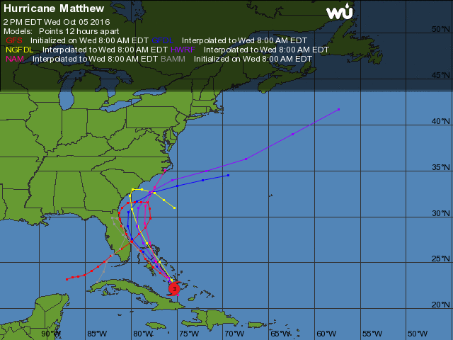
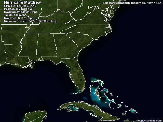
The storm is forecast to impact Florida today, possibly as a Category 4 storm. If it makes landfall, it would be the most powerful storm since Hurricane Wilma in 2005 to do so, and could cause as much as $15 billion in economic disruption
Updated Oct 7th 2016

Pilots from the National Oceanic and Atmospheric Administration fly directly into Hurricane Matthew and collect valuable data from the storm. Video shows the pilots battling severe turbulence before they finally break through the eye wall to relative calm. Hurricane Matthew is currently hitting the East coast of Florida and is expected to continue traveling up the coast for the next 2 days.
Video: CAPT Tim Gallagher/NOAA
More than forty F-15E Strike Eagles from Seymour Johnson AFB, NC have been relocated to Barksdale AFB, LA to avoid any potential damage from Hurricane Matthew. The large force movement also included six KC-135R Stratotankers and over 200 Airmen. Filmed on October 6, 2016.
 Quyền Sử Dụng Ở Diễn Ðàn

 Trả Lời Với Trích Dẫn